Nearly VND 9.9 Trillion Proposed for Le Van Luong Road Expansion: A New Strategic Transport Corridor for Southern Ho Chi Minh City
By Axen Property Vietnam
Ho Chi Minh City is studying a major project to upgrade and expand Le Van Luong Road, with a preliminary total investment of nearly VND 9.9 trillion. The project is expected to become one of the most important infrastructure developments aimed at reducing congestion, addressing recurring flooding, and strengthening connectivity between southern Ho Chi Minh City and neighbouring southwestern areas.
The Ho Chi Minh City Department of Construction is currently preparing the project proposal and completing the necessary documentation based on the city’s medium-term public investment plan for the 2026–2030 period.
Subject to approval and implementation as scheduled, the project would not only increase the traffic capacity of Le Van Luong Road but could also create a new development corridor through Nha Be, Hiep Phuoc, and the southern gateway of Ho Chi Minh City.
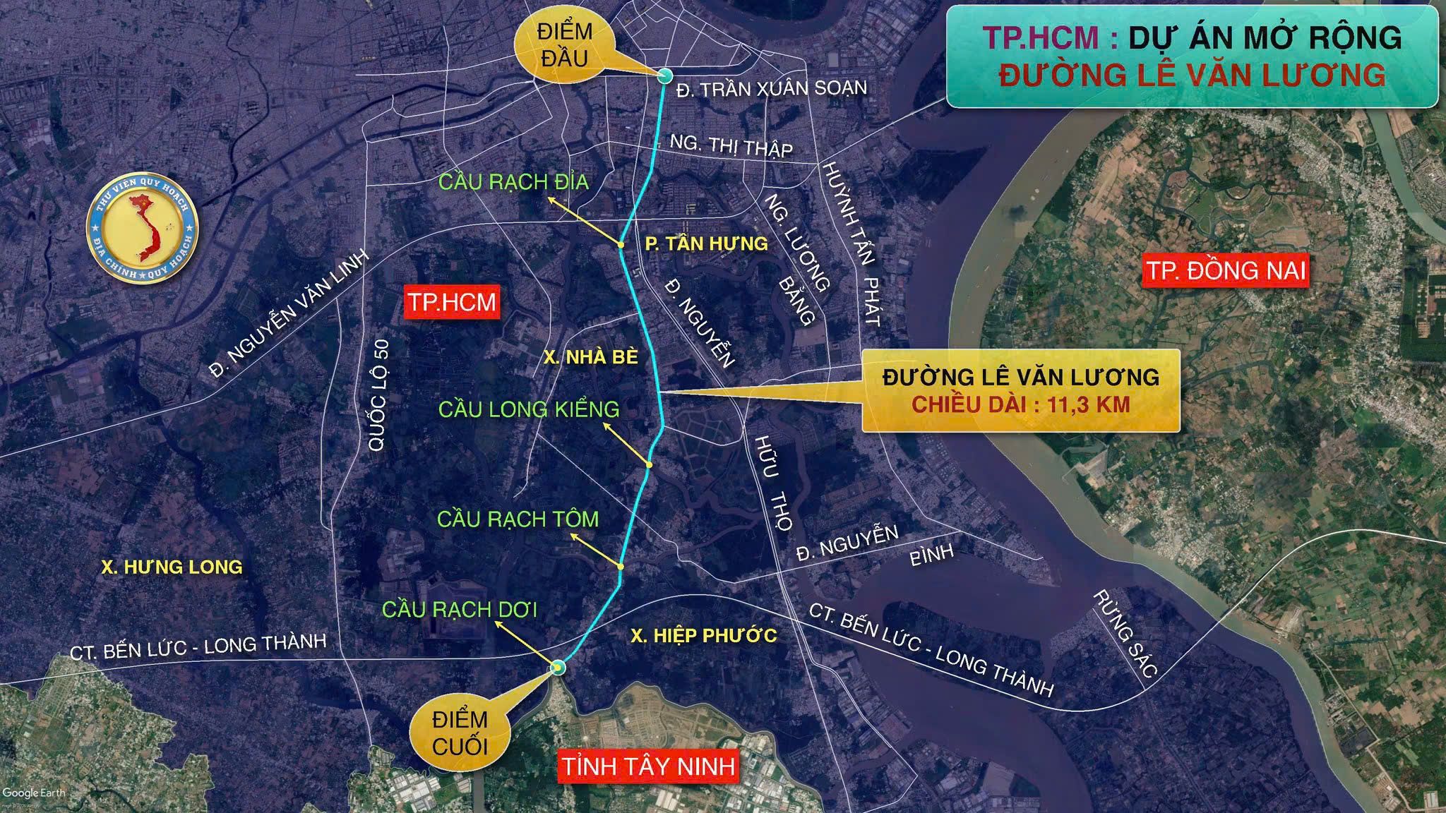
Proposed Le Van Luong Road corridor extending from the Tran Xuan Soan area through Nha Be and Hiep Phuoc to Rach Doi Bridge. Source: Thu Vien Quy Hoach
Proposed scope of the Le Van Luong Road expansion
Under the proposal currently being studied, the Le Van Luong Road corridor would have a total length of approximately 11.3 kilometres.
The proposed route would begin at the intersection with Tran Xuan Soan Street in Tan Hung Ward and continue south through Nha Be before ending at Rach Doi Bridge in Hiep Phuoc Commune.
The road is expected to be widened to between 30 and 40 metres, in line with the planned 40-metre right-of-way.
The preliminary total investment is estimated at nearly VND 9.9 trillion. More than VND 6.5 trillion of this amount would be allocated to compensation, support, resettlement, and site clearance.
Key project information
[@portabletext/react] Unknown block type "table", specify a component for it in the `components.types` prop
The proposed construction and completion dates remain preliminary. The actual schedule will depend on investment approval, capital allocation, site clearance, resettlement, and the timely handover of construction sites.
Why does Le Van Luong Road need to be expanded?
Le Van Luong Road is an important north–south transport axis in southern Ho Chi Minh City.
The road connects the former District 7 area with Nha Be and Hiep Phuoc before extending towards neighbouring southwestern localities. It also serves residential areas, industrial zones, logistics facilities, and several major development areas in southern Ho Chi Minh City.
Despite its strategic role, the road’s current condition does not meet growing transport demand. Many sections remain narrow, with limited traffic capacity, while the volume of private vehicles, trucks, and commercial traffic continues to increase.
The corridor currently faces three major infrastructure pressures.
Congestion at narrow bridges and intersections
Le Van Luong Road crosses several rivers and canals, including locations served by Rach Dia Bridge, Long Kieng Bridge, Rach Tom Bridge, and Rach Doi Bridge.
These bridges have historically created bottlenecks because their capacity and approach roads have not always been consistent with traffic demand.
Some bridges have already been rebuilt or are being considered for separate investment. However, replacing individual bridges without widening the connecting road sections would not fully resolve congestion along the corridor.
The expansion of Le Van Luong Road therefore needs to be coordinated with bridge development, intersection upgrades, drainage systems, and overall traffic management.
Flooding during heavy rain and high tides
Nha Be has relatively low ground elevation and is strongly affected by rivers, canals, and tidal conditions. Several sections of Le Van Luong Road are vulnerable to flooding when heavy rainfall occurs at the same time as high tides.
For this reason, the project should not be treated solely as a road-widening scheme.
The investment plan needs to address road elevation, drainage capacity, culvert systems, discharge outlets, and the wider movement of surface water across the surrounding area.
Raising the road without developing a coordinated drainage solution could redirect water towards nearby residential neighbourhoods.
Rapid urbanisation in Nha Be
Nha Be has experienced significant residential and urban development, along with growing demand for connections to Phu My Hung, central Ho Chi Minh City, Hiep Phuoc, and other southern areas.
However, much of the existing transport network is still based on older rural road structures with limited capacity.
The widening of Le Van Luong Road is therefore important for balancing population growth and urban development with the area’s transport infrastructure.
More than 65% of the investment may be used for site clearance
More than VND 6.5 trillion of the proposed VND 9.9 trillion investment would be allocated to compensation and site clearance.
This means land-related costs could account for roughly two-thirds of the project’s preliminary total investment.
The high proportion reflects one of the project’s most significant challenges.
Le Van Luong Road passes through established residential areas containing homes, businesses, utilities, and other existing structures. Expanding the road from its current narrow condition to a width of 30–40 metres would require the acquisition of a substantial amount of land along both sides of the corridor.
The site-clearance process may involve:
Confirming the final land-acquisition boundary.
Surveying houses, land plots, and assets attached to the land.
Reviewing the legal status and origin of individual properties.
Preparing compensation, support, and resettlement plans.
Relocating electricity, water, telecommunications, and other utilities.
Handing over cleared land in phases for construction.
Even when the investment policy is approved on schedule, actual construction will depend heavily on how quickly these procedures can be completed.
More than a road-widening project
The project should not focus solely on adding traffic lanes.
A modern urban road with a width of 30–40 metres should be developed as a complete infrastructure corridor, integrating transport, drainage, landscaping, lighting, pedestrian facilities, and utility systems.
Drainage infrastructure
The drainage network should be designed based on local catchment areas, ground elevation, rainfall intensity, and tidal conditions.
The system must be capable of handling heavy rainfall, particularly when it coincides with high tides.
Pavements and pedestrian space
Urban development along the corridor will increase demand for safe pedestrian access to homes, schools, businesses, and public services.
Continuous pavements should be provided and protected from obstruction or excessive interruption by vehicle entrances.
Trees and street lighting
Trees could reduce surface temperatures, improve the streetscape, and create a protective buffer between pedestrians and traffic.
A coordinated lighting system would also improve safety, especially along sections passing through less densely populated areas or locations near canals and rivers.
Underground technical infrastructure
Electricity, water supply, telecommunications, and other utility networks should be arranged within properly planned technical corridors.
This approach would help prevent repeated road excavation after the project has been completed.
Traffic organisation and intersections
Widening the road alone would not prevent congestion if major intersections remain unchanged.
Connections with Nguyen Van Linh Boulevard, Nguyen Huu Tho Street, Nguyen Binh Street, and local residential roads should be carefully designed with turning lanes, traffic signals, and suitable U-turn arrangements.
The importance of bridges along the corridor
The proposed route crosses several rivers and canals, making the project more technically complex than a conventional urban road expansion.
Important bridges along the corridor include Rach Dia Bridge, Long Kieng Bridge, Rach Tom Bridge, and Rach Doi Bridge.
Rach Dia Bridge
Rach Dia Bridge is located near the connection between the former District 7 area and Nha Be.
It carries traffic from surrounding areas, including Nguyen Huu Tho Street, Nguyen Thi Thap Street, and nearby residential neighbourhoods.
Long Kieng Bridge
Long Kieng Bridge is a major link along Le Van Luong Road.
The development of a new bridge has helped remove a long-standing bottleneck. However, its full transport capacity can only be realised when the adjacent road sections are widened accordingly.
Rach Tom Bridge
The Rach Tom Bridge area connects several residential zones in southern Nha Be.
Infrastructure development in this area should be coordinated with future urban planning and expected increases in traffic volume.
Rach Doi Bridge
Rach Doi Bridge marks the southern end of the proposed road-expansion corridor and plays an important role in connecting Ho Chi Minh City with neighbouring areas.
If Rach Doi Bridge and Le Van Luong Road are developed in a coordinated manner, the entire route could become a higher-capacity interprovincial transport corridor.
Improved connectivity between South Saigon and Hiep Phuoc
One of the project’s most important expected benefits is improved access to Hiep Phuoc.
Hiep Phuoc occupies a strategic position in southern Ho Chi Minh City, with significant industrial, logistics, port, and residential development.
However, access currently depends heavily on Nguyen Huu Tho Street, Nguyen Van Linh Boulevard, National Highway 50, and several local roads with limited capacity.
Once expanded, Le Van Luong Road could become an additional parallel route, helping redistribute traffic and reduce dependence on existing main corridors.
The route may also connect with the Ben Luc–Long Thanh Expressway in the southern area, improving east–west mobility and regional logistics connections.
However, the actual effectiveness of this connection will depend on interchange locations, access roads, and the way traffic is organised between Le Van Luong Road and regional infrastructure projects.
Could the project reduce pressure on National Highway 50?
Le Van Luong Road could potentially share part of the traffic demand currently placed on National Highway 50, particularly for journeys between southern Ho Chi Minh City and neighbouring southwestern areas.
However, the two corridors would not completely replace one another.
National Highway 50 serves a separate transport corridor through Binh Chanh and towards Can Giuoc, while Le Van Luong Road runs through Nha Be and continues towards Rach Doi Bridge.
Its ability to reduce pressure on National Highway 50 will depend on:
The completion and capacity of Rach Doi Bridge.
The quality of roads beyond the Ho Chi Minh City boundary.
Connections with the surrounding provincial road network.
Traffic management for trucks and private vehicles.
Interchanges with the Ben Luc–Long Thanh Expressway.
The implementation schedules of related infrastructure projects.
Le Van Luong Road should therefore be regarded as an additional corridor for the southern gateway rather than a complete substitute for National Highway 50.
Potential impact on southern Ho Chi Minh City’s property market
A transport project with an estimated investment of nearly VND 9.9 trillion is likely to attract significant attention from the real estate market.
Areas that may receive increased interest include:
Tan Hung Ward and the former District 7 area.
Phuoc Kien and other parts of Nha Be.
Long Kieng and Nhon Duc.
The Nguyen Binh area.
Hiep Phuoc.
Residential communities near Rach Doi Bridge.
Potential benefits could result from shorter travel times, improved accessibility, and higher-quality urban infrastructure.
However, not every property located near the road would benefit equally.
Properties that may benefit
Properties with clear legal status, convenient access, and locations outside the land-acquisition boundary may gain greater utility and long-term value after the infrastructure is completed.
Properties near well-designed intersections and connecting roads could also benefit from improved accessibility.
Properties that may be negatively affected
Homes and land located within the planned right-of-way could be partially or fully acquired.
Remaining land plots may also change in shape, setback requirements, or development potential after site clearance.
Properties situated extremely close to a major road could face increased noise, dust, and traffic volume.
Buyers and investors should therefore not evaluate properties solely on the basis that they are located “near Le Van Luong Road.”
Important factors to verify include:
The official planned right-of-way.
The confirmed land-acquisition boundary.
Land-use planning.
Property ownership and legal documentation.
Distance from major intersections.
Future access after traffic reorganisation.
The actual progress of investment approval and site clearance.
Proposed implementation schedule from 2026 to 2029
In 2026, the Ho Chi Minh City Department of Construction is expected to continue completing the project documentation based on the city’s medium-term public investment plan for the 2026–2030 period.
The investment proposal is expected to be submitted to the Ho Chi Minh City People’s Council for consideration during its third-quarter meeting in 2026.
The expected implementation schedule is as follows:
2026: Complete the project report, investment documentation, appraisal procedures, and investment-policy submission.
2027: Begin construction, subject to approval, funding arrangements, and the availability of cleared land.
2027–2029: Carry out construction in phases and coordinate the development of roads, bridges, drainage, lighting, and related technical infrastructure.
2029: Target completion of the entire corridor.
This is not yet an official construction schedule. The dates may change depending on investment approval, site clearance, capital allocation, and actual implementation conditions.
Key issues that still require monitoring
Before the feasibility and impact of the project can be assessed more fully, several details still need to be officially confirmed:
The exact project boundary approved by the authorities.
The final route length and investment phases.
The road width applied to each section.
The official site-clearance boundary.
The scale and construction plan for Rach Doi Bridge.
The total investment after appraisal.
The funding source and disbursement schedule.
The drainage and flood-prevention design.
The connection with the Ben Luc–Long Thanh Expressway.
The schedule for land handover in existing residential areas.
Expectations for a new arterial corridor in southern Ho Chi Minh City
The expansion of Le Van Luong Road would have significance beyond that of a local road project.
Once roads, bridges, and drainage systems are developed in a coordinated manner, the corridor could become one of the most important transport routes in southern Ho Chi Minh City.
It could strengthen connections between central urban areas, the former District 7 area, Nha Be, Hiep Phuoc, and neighbouring localities.
The project may also help redistribute traffic, reduce pressure on existing routes, and support more efficient use of urban land in the southern part of the city.
Nevertheless, the project remains in the study and investment-preparation stage.
The proposed targets of beginning construction in 2027 and completing the route in 2029 will only be achievable if investment approval, capital arrangements, compensation, and site clearance are completed on schedule.
The project is therefore an important infrastructure development to watch, but residents and investors should continue following official decisions rather than treating the proposed timeline as guaranteed.
Information sources: Ho Chi Minh City Department of Construction and publicly available information regarding the city’s medium-term public investment plan for the 2026–2030 period.